language
En Ku Ar

Image Title calendar2024-01-28

Human Landscape - Site (Trans-) Formation in the Transtigris Area

he formation of Ear per rone Age centres in pesopotamia is the resut of ong term processes hich can be e pained b en ironmenta economica and socia de eopments heir phsica appearance is not on a testimon of centrai ation but aso of the socia eoution relected in its impact on andscapes Large te sites surrounded b a eb of roads for inter-regiona and inter-site communication traceabe through aeria and sate ite photograph ofer a testing ground for ne methods hie the pains of northern S ria ha e itte ariation in terrain the centra Trans‐Tigris area sho s a high diferentiated terrain afected b the ridges of the agros iedmont one 

Image Title calendar2024-01-28

In the land of the highlanders: from the kingdom of Simurrum to Mazamua in the Shahrizor

In the late third and early second millennium bc, the large plain known today as the Shahrizor and its surrounding region, located in the province of Suleymaniyah in Iraqi Kurdistan, likely formed an important region of the kingdom of Simurrum (Fig. 31.1; Altaweel et al. 2012). For much of the remaining second millennium bc and into the irst two centuries of the irst millennium bc, the region was a contested border zone between northern and southern Mesopotamian kingdoms or became splintered into small kingdoms.

Image Title calendar2024-01-29

Excavations at Shaikh Marif, Iraqi Kurdistan Preliminary Report of the First Season (2022)

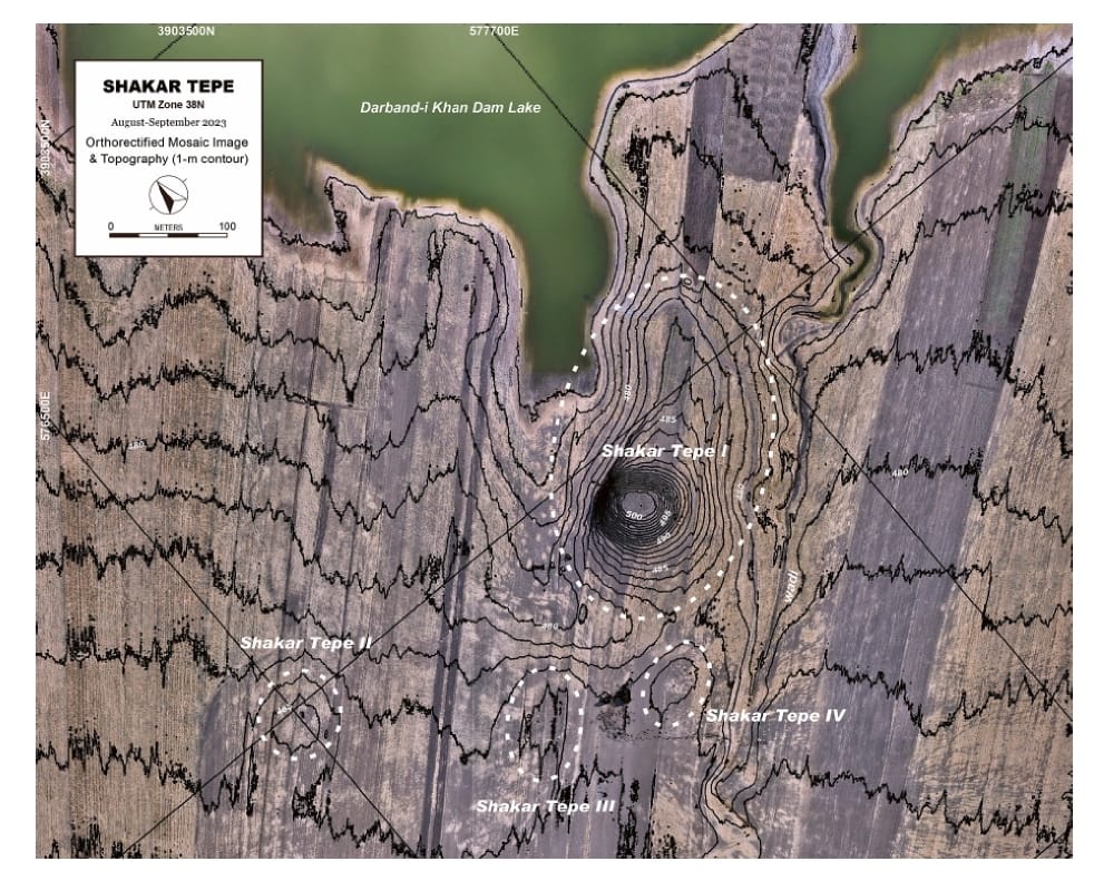
Grdi-Shaikh Marif The archaeological site of Shaikh Marif, located in the Shahrizor Plain ca. 500 m south of Gird Shamlu along the Wadi Shamlu, was registered by the Iraq Museum in 1943. In November 2012, the Shahrizor Survey Project additionally identified several new artificial mounds near Shaikh Marif. Among them, a cluster of two tiny mounds is called, together with Shaikh Marif itself, “Se Tapanسێ تەپان ” by the local people, and thus all three mounds were designated “Shaikh Marif”: Shaikh Marif I (the original northern mound), Shaikh Marif II (a western mound also called “Ash Shaikh Marif” by the locals), and Shaikh Marif III (an eastern mound). The land is seasonally cultivated today, and the water of the Darband-i Khan Dam Lake occasionally covers almost entire areas of the mounds. Owing to modern cultivation and the erosion by flowing water, a large amount of archaeological materials were easily observed on the surface. While no prehistoric material was identified at Shaikh Marif III, numerous Late Neolithic potsherds were scattered across the other two mounds as well as the materials dated to the younger periods. The date of these Late Neolithic sherds was estimated to be ca. 6400 6000 BC. A Japanese archaeological team (directed by Takahiro Odaka, Kanazawa University) excavated Shaikh Marif II in 2022 and revealed the Late Neolithic layers, which directly accumulated on the virgin soil. Most of the finds were dated to ca. 6100-6000 BC, although a small amount of the artefacts from the historical periods indicate human activities in the middle Medieval and the Ottoman Periods.

10,000 years ago one of the earliest villages on the Shahrizor Plain was built and lived in at the nearby settlement mound of Bestansur

Article Name

Early Settled Communities

10,000 years ago one of the earliest villages on the Shahrizor Plain was built and lived in at the nearby settlement mound of Bestansur. At that time communities were developing new ways of living that form the foundation of our lives today. Communities were changing from mobile hunter-gathering ways of life to larger communities living in well-built mud brick houses supported by early agriculture, growing crops and managing and domesticating animals, while continuing to use a wide range of wild plant and animal resources.

The site was first surveyed by the Iraqi Directorate of Antiquities and Heritage in 1943. From 2012 large scale archaeological excavations have been conducted by a joint team from Slemani Directorate of Antiquities and Heritage, and the University of Reading, UK.

Abundant Water and Biodiverse Environments

The large spring here is fed by clear underground waters from the mountains. These plentiful waters and the fertile soils and hills have provided bio diverse environments for people, plants, and animals for many thousands of years.

This area attracted the earliest farmers here 10,000 years ago. They fished, hunted wild boar and harvested reeds in the marshes and river. They grew crops, herded goat and gathered wild plants and snails on the plain and hilly slopes.

Today only 4% of the total mammal biomass on the planet is wild. To preserve these rich water-supplies, farmlands and wildlife, we need to protect them from climate change, pollution and other threats.

Daily Life in the Neolithic

The people who first lived here made their houses from mud bricks and built clay ovens to cook their food and keep warm. They used large pestles and mortars to grind plants, nuts, and grain, and they shaped tools and knives from chert and obsidian (volcanic glass). People harvested reeds from the river to make baskets and mats. They used bone needles to sew materials such as animal skins, often using their teeth as a ‘third hand’.

People were connected 10,000 years ago through networks of communities who exchanged materials, technologies, and ideas.  The Neolithic villagers of Bestansur used locally available materials for everyday life and resources from hundreds of kilometers away. At Bestansur we find stones such as obsidian and carnelian from Türkiye and Iran, and shells from the Red Sea.

People in the Neolithic village used natural materials for their daily life and repaired objects when they broke. Such practices were more sustainable and better for the environment than the plastics that we use today and then throw away.