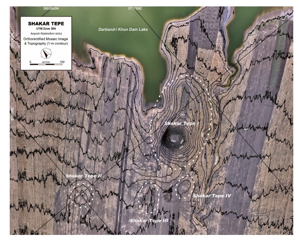
The Shahrizor Plain is one of the ideal fields for tracking the transition from Neolithic village life in the Fertile Crescent to Urbanisation which occurred in Mesopotamia because of its geographical location connecting the mountainside valleys along the Zagros and the downstream Diyala River that flows into the Tigris. Our field project aims to obtain archaeological materials to unveil this process. Following the first excavations at Shakar Tepe conducted in 2019, we excavated two additional areas at this site in 2023, including one of the three satellite mounds that were newly identified around the main mound. The cultural remains of the Late Halaf settlement uncovered from Operation B at Shakar Tepe II date back to approximately 5600–5400 calBC. On the other hand, Operation C at Shakar Tepe I yielded a thick deposit of the Late Chalcolithic occupations dated to ca. 3800–3600 calBC. The recovered materials fill the time ranges in the late prehistoric chronology of the site and will contribute to our understanding of the historical role of this region in the transition from Neolithisation to Urbanisation.
The Shahrizor Plain is one of the ideal fields for tracking the transition from Neolithic village life in the Fertile Crescent to Urbanisation which occurred in Mesopotamia because of its geographical location connecting the mountainside valleys along the Zagros and the downstream Diyala River that flows into the Tigris. Our field project aims to obtain archaeological materials to unveil this process. Following the first excavations at Shakar Tepe conducted in 2019, we excavated two additional areas at this site in 2023, including one of the three satellite mounds that were newly identified around the main mound. The cultural remains of the Late Halaf settlement uncovered from Operation B at Shakar Tepe II date back to approximately 5600–5400 calBC. On the other hand, Operation C at Shakar Tepe I yielded a thick deposit of the Late Chalcolithic occupations dated to ca. 3800–3600 calBC. The recovered materials fill the time ranges in the late prehistoric chronology of the site and will contribute to our understanding of the historical role of this region in the transition from Neolithisation to Urbanisation.
The archaeological mission from the University of Tsukuba began to investigate the Neolithic sites in the Iraqi-Kurdistan region in 2014. The purpose of our investigations was to reconsider the issue of Neolithization in Iraqi-Kurdistan, where research began in the 1940s and 50s and was stalled by political issues starting in the 1960s. With the full support of the Directorate General of Cultural Heritage of the Ministry of Culture of the Kurdistan Regional Government and the Slemani Department of Cultural Heritage, we first began our research at the Qalat Said Ahmadan site, located in the Pshdar Plain. We were able to identify the cultural deposits of the end of the Pre-Pottery Neolithic period, those of the Hassuna, Samarra, Halaf, Ubaid, and Iron Age, and have clarified the nature of the Neolithic site located at the edge of the fan deposits [Tsuneki et al. 2015, 2016, 2019].
240307025048.png)
The south-western foothills of the Zagros range, in Iraqi Kurdistan, have long been largely unexplored because it has been impossible for archaeologists to carry out fieldwork research in this area for more than half a century.
240128080616.png)
he formation of Ear per rone Age centres in pesopotamia is the resut of ong term processes hich can be e pained b en ironmenta economica and socia de eopments heir phsica appearance is not on a testimon of centrai ation but aso of the socia eoution relected in its impact on andscapes Large te sites surrounded b a eb of roads for inter-regiona and inter-site communication traceabe through aeria and sate ite photograph ofer a testing ground for ne methods hie the pains of northern S ria ha e itte ariation in terrain the centra Trans‐Tigris area sho s a high diferentiated terrain afected b the ridges of the agros iedmont one
240128080352.png)
Im Rahmen eines Forschungsprojektes begab sich ein bayerisches Prospekti onsteam im Oktober des vergangenen Jahres auf eine Forschungsexpedition in den Nordostirak, genauer in die süd kurdischen Provinzen Sulaymaniyah und Halabjah. Hier in der Shahrizor Ebene, nahe der irakisch-iranischen Grenze, sollten an drei Fundorten Un tersuchungen durchgeführt werden.
240128080157.png)
Archaeological features, such as architecture etc. can be traced by high resolution and large-scale magnetometer prospecting. Moreover, soil magnetic data deliver additional information about the alteration of the ancient landscape. In combination with an archaeological survey, the geophysical results can provide information to reconstruct the spatial organization within these settlements as well as an epoch-spanning analysis of settlements and their role in urbanization processes and within settlement hierarchies.
240128075940.png)
In the late third and early second millennium bc, the large plain known today as the Shahrizor and its surrounding region, located in the province of Suleymaniyah in Iraqi Kurdistan, likely formed an important region of the kingdom of Simurrum (Fig. 31.1; Altaweel et al. 2012). For much of the remaining second millennium bc and into the irst two centuries of the irst millennium bc, the region was a contested border zone between northern and southern Mesopotamian kingdoms or became splintered into small kingdoms.
240128075418.png)
Recent palaeoenvironmental, historical, and archaeological investigations, primarily consisting of site reconnaissance, in the Shahrizor region within the province of Sulaymaniyah in Iraqi Kurdistan are bringing to light new information on the region’s social and socio-ecological development.
Grdi-Shaikh Marif The archaeological site of Shaikh Marif, located in the Shahrizor Plain ca. 500 m south of Gird Shamlu along the Wadi Shamlu, was registered by the Iraq Museum in 1943. In November 2012, the Shahrizor Survey Project additionally identified several new artificial mounds near Shaikh Marif. Among them, a cluster of two tiny mounds is called, together with Shaikh Marif itself, “Se Tapanسێ تەپان ” by the local people, and thus all three mounds were designated “Shaikh Marif”: Shaikh Marif I (the original northern mound), Shaikh Marif II (a western mound also called “Ash Shaikh Marif” by the locals), and Shaikh Marif III (an eastern mound). The land is seasonally cultivated today, and the water of the Darband-i Khan Dam Lake occasionally covers almost entire areas of the mounds. Owing to modern cultivation and the erosion by flowing water, a large amount of archaeological materials were easily observed on the surface. While no prehistoric material was identified at Shaikh Marif III, numerous Late Neolithic potsherds were scattered across the other two mounds as well as the materials dated to the younger periods. The date of these Late Neolithic sherds was estimated to be ca. 6400 6000 BC. A Japanese archaeological team (directed by Takahiro Odaka, Kanazawa University) excavated Shaikh Marif II in 2022 and revealed the Late Neolithic layers, which directly accumulated on the virgin soil. Most of the finds were dated to ca. 6100-6000 BC, although a small amount of the artefacts from the historical periods indicate human activities in the middle Medieval and the Ottoman Periods.
Grdi-Shakar Tapa on the Sharazor plain in Iraq's Kurdistan Region has revealed a new episode of the Neolithic discovery Shakar Tapa has been known as a conspicuous archaeological site in the south of the Shahrazor Plain since the mid-20th century. It has an oval plan consisting of a low northeastern mound and a high conical southwestern mound with a flat top. The Darband-i Khan Dam Lake is adjacent to the north of the site and its water occasionally reaches the skirt of the mound, causing crucial erosion of the northern edge of the mound. Many archaeological materials were collected on the surface of Shakar Tapa in the past. Although most of them can be dated to the historical ages, such as the Early-to-Middle Bronze Age, the Iron Age, and the Parthian-Sasanian Period, some artefacts were certainly dated to the prehistoric period. In 2019 a Japanese archaeological team (directed by Takahiro Odaka, Kanazawa University) started the excavations of Shakar Tapa to investigate its late prehistoric occupation. The first operation of a step trench was set at the northwestern skirt of the high mound and yielded the Ubaid deposit and the Late Neolithic stratigraphic sequence covering ca. 6400-6000 BC. Virgin soil was reached at the northwestern end of the trench about 5 m below the highest level of this trench. The second season carried out in 2023 revealed the younger Late Chalcolithic deposit at the area near the trench in 2019. In addition, a few low satellite mounds were identified west of the main mound and another late prehistoric deposit was uncovered at one of them.